Browse categories
I will do gis georeferencing and digitization of maps with HQ precission, arcgis, qgis

Peter B.
Level 2
Peter B.
Level 2


What people loved about this freelancer
bridgeway36

United States
I personally didn't understand what I needed or who could provide it, I don't know anything about geofencing but Peter does and it included everything I needed...
bridgeway36
United States
Thank you for the follow-up work that confirms the original findings. This is the key to my case. I truly appreciate your service and abilities.
nordhusen

Germany
Peter was really quick in understanding the specifications of the project and delivered quickly. Requests for changes have been understood and included in the...
About this gig
Hello,
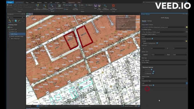
I have experience working with more than 600 data sources, many of which are in PDF format, as well as raster PNG or vectors like as Shapefiles or CAD data formats. I have vectorized more than 24,000 objects.
I have collaborated as a design team manager and spatial quality data inspector adhering to the standards of the European Union and the Open Geospatial Consortium (OGC).
My projects have been completed and published on goverment web maps in Poland and the European Union.
I realized at Fiverr projects from North and South America, Europa, Asia, Australia and Oceania in total 20+ unique countries and multiple languages data.
I can perform georeferencing and digitization tasks to meet market needs for:
- Cadastral Maps
- Urban Plans
- Engeenering utilities
- Digital terrain models
- Technical Maps
- Real Estate locations
- etc.
Do you need stack of maps more than 10?
Check out my 10x package offer on my next GIG offer with better price!
Now, its your turn!
Get to know Peter B.
Peter B.
Fluently resolve any visual and locations issues Thumb up
Level 2
Peter B. is part of the Fiverr Pro catalog and has been hand-picked by a dedicated Fiverr Pro team for their skills and expertise.
Expert in:
Data Processing
- FromPoland
- Member sinceNov 2021
- Avg. response time2 hours
- Last delivery2 days
Languages
English, Polish
✔️ GIS Mapping Specialist -
I'm eager to bring my GIS expertise to your project and deliver results that exceed your expectations.
🚀 Interactive Web Map Developer -
I look forward to the opportunity to create an engaging and intuitive web map that aligns perfectly with your vision
🔍 Spatial Data Management Consultant -
I'm ready to apply my extensive data management skills to help you leverage spatial insights for your strategic goals
😉 I love the visualization task, automatic processing, datasets and sports activity
👋 Let’s talk
- NYC dataset - Real Estate Excel
- +1yr Real Estate - RED Labs
- Power network - Spatial Database
- Power Network - Machine learing
- Web map zoning - NYC Real estate
Offers hourly rates
Pay by the hour, as reported by the freelancer.
FAQ
What file format should I provide?
Any formats, but first check this files or link it's not damage
What file format you might deliver?
Any raster: GeoTIFF, GeoPDF, tile service, etc. Any georeferencing raports: pdf, txt, csv, etc. Any vector: .GeoJSON, GeoPackage, Shapefile, GML, Geodatabase, etc*
What file resolution It's minimum for geoprocessing?
It is depends of file size and scale map. In my experience, If you zoom in to 200-300 % and text is readability it good quality.
What kind of tests algorithms do you use?
- Raster transformation type: 2nd polynomial or 3rd polynomial (If error is too high) - Topology validation: OGC Version 1.2.0 - Interpolation Type: NearestNeighbour or Cubic
Reviews
49 reviews for this Gig
| (49) | ||
| (0) | ||
| (0) | ||
| (0) | ||
| (0) |
Rating Breakdown
- Seller communication level
- Recommend to a friend
- Service as described
Sort By
Most relevant
- United States
I personally didn't understand what I needed or who could provide it, I don't know anything about geofencing but Peter does and it included everything I needed for my case. I especially appreciate the explainatory video with the images, and...
- United States
Thank you for the follow-up work that confirms the original findings. This is the key to my case. I truly appreciate your service and abilities.
- Germany
Peter was really quick in understanding the specifications of the project and delivered quickly. Requests for changes have been understood and included in the project asap. Would definately recommened him and work again with him soon.
- United States
Exceptional as always. Thank you!
- United States
Solid quality work, and familiar with the general GIS standards so made delivery a breeze.
