Browse categories
I will digitize any scanned image and create gis shapefile layers
Mapnology: Map Development For The World
We are a professional GIS company with 10 years webmapping experience and 15 years of programming experience.
We can help you solve any kind of mapping, cartography and spatial database related pr...
Expert in:
Data Entry
About this Gig
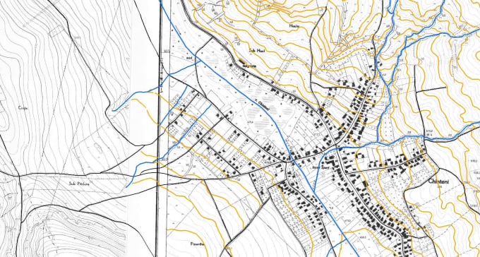
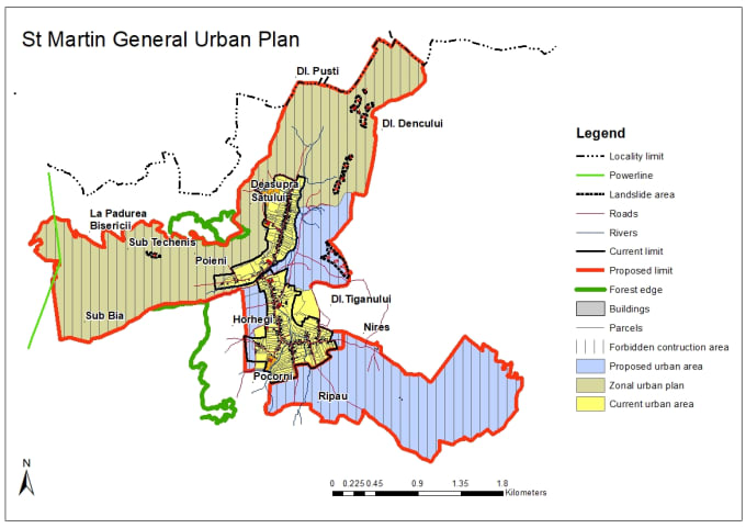
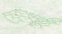
I can digitize (vectorize, trace) different layers from any kind of scanned maps. Examples include: extracting buildings or roads from satellite image, tracing features from any kind of historical, geology, climate, etc. map, parcels or construction site work evolution from aerial images...
I will create the layer structure and can do data entry in the attributes table up to three columns of values. I can store data in shapefiles or spatial databases (PostGIS). I will make sure that I deliver good quality digitizing for every map which includes lots of detail and good accuracy. I will not store your data and ensure you for your data privacy.
If the data are not georeferenced (image coordinates are not linked to real world coordinates) I can do that too, provided you can give me some information on the location of the image or features that can be found in the real world.


Type:
Convert data
•
Insert data
•
Tagging
•
Merge data
Tool:
Other spreadsheets
Offers hourly rates
Pay by the hour, as reported by the freelancer.
FAQ
Is my data safe with you?
I will not store any of your data (images or digitized layers) for more than 48 hours after the delivery of the work and your confirmation. Your data is safe and I will not use it in any way or give it to anyone. If you need me to reuse it in the future I can store it by your request
What software will you use?
I will use QGIS for digitizing and deliver the data in shapefile format. This format is compatible with other GIS software out there like ArcGIS/GRASS/gvSIG,uDig, etc. I can also send you an SQL file to insert in a PostGIS database or a file you can import in an ArcGIS geodatabase.
What is your experience with this work?
I digitized hundreds of maps of all kinds (topographic maps, historical maps from around 1900, satellite images). I am proficient in QGIS and ArcGIS software and can do both digitizing, 3D modelling and spatial analysis of data.
Why can't I just get my data from some free online data source?
There are free online data sources (government agencies, Natural Earth Data, OpenStreetMap, etc.) that offer free data. However, these data may be at a lower scale, without required attributes or not validated. I will also get data from historical/geology/economic/parcel.. maps and custom attribute
Reviews
16 reviews for this Gig
| (16) | ||
| (0) | ||
| (0) | ||
| (0) | ||
| (0) |
Rating Breakdown
- Seller communication level
- Recommend to a friend
- Service as described
Sort By
Most relevant
 Germany
Nice work and nice communication!
 Cambodia
It's my 2nd time working with Matei. Same as before: fast response, quick work completion and great quality!
- Cambodia
Very professional and responsive. Provided exactly what was promised and very fast. The input data was challenging because based on poor quality map pictures (bad angle and not very clear pictures), but the seller was able to extrapolate the pictures into valid data points. Well done job!
 Netherlands
The Seller was very clear an told me exactly what where the possibilities of this order
 United States
Very good communication and delivered what I was looking for. I needed to have a subdivision overlay created and also bring in USGS aerial and sectional lines to help with a legal position. Matei was great to work with and very responsive!
Reviews
16 reviews for this Gig
| (16) | ||
| (0) | ||
| (0) | ||
| (0) | ||
| (0) |
Rating Breakdown
- Seller communication level
- Recommend to a friend
- Service as described
Sort By
Most relevant
- Germany
Nice work and nice communication!
- Cambodia
It's my 2nd time working with Matei. Same as before: fast response, quick work completion and great quality!
- Cambodia
Very professional and responsive. Provided exactly what was promised and very fast. The input data was challenging because based on poor quality map pictures (bad angle and not very clear pictures), but the seller was able to extrapolate the pictures into valid data points. Well done job!
- Netherlands
The Seller was very clear an told me exactly what where the possibilities of this order
- United States
Very good communication and delivered what I was looking for. I needed to have a subdivision overlay created and also bring in USGS aerial and sectional lines to help with a legal position. Matei was great to work with and very responsive!
