Browse categories
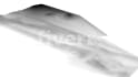
I will create custom gis maps for your data visualization needs

Chalitha Prabha
Top Rated
Chalitha Prabha
Top Rated


About this gig
Hello!
I specialize in GIS Analysis and Remote Sensing, with 5+ years of experience in delivering comprehensive mapping services to various industries.
Services:
- GIS Mapping: Data collection, georeferencing, analysis, and management using ArcGIS, QGIS, GRASS GIS and more.
- Remote Sensing: Image analysis, classification, change detection from satellite imagery, LIDAR, aerial photos, and more.
- Interactive Mapping: Develop dynamic maps with Mapbox, Leaflet, Google Maps API, featuring pop-ups, layer controls, and real-time updates.
- Custom Scripts: Python and MATLAB geoprocessing scripts for automation and unique spatial analyses.
- Customized Map Creation: Tailored thematic, location, heat, topographic maps with a focus on design and information.
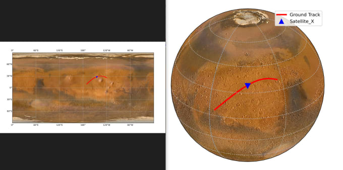
- Explore the Cosmos: Go beyond Earth's boundaries and unlock the mysteries of celestial bodies. Visualize captivating maps of lunar, Martian, and other celestial landscapes based on available data. Witness the wonders of outer space through stunning visualizations.
Note: Contact me before placing an order to discuss project details. Let's bring your mapping vision to life!
Get to know Chalitha Prabha
Chalitha Prabha
Top Rated
- FromSri Lanka
- Member sinceOct 2018
- Avg. response time1 hour
- Last deliveryabout 16 hours
Languages
English
GIS & Remote Sensing expert (5+ yrs), proficient in Python, R, MATLAB, C, JS, Java with a research background. BSc Geology & Computer Science, MSc GIS & Remote Sensing. Specialized in spatial analysis, cartography, data management. Expert in GIS software, research, machine learning/AI, cloud computing. Committed to data privacy, ethics, & top-tier results. I'm ready to ensure your project's success with my programming & research-driven approach.
Let's make your project a success!
- Mars Satellite Orbit Map
- Interactive GeoMapping Tool
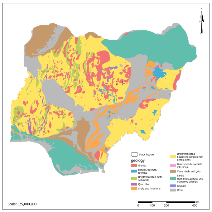
- Estimation of Lithium-Pegmatites
FAQ
How do I get started with my map project?
To get started, simply reach out to me via the contact options provided. We will discuss your specific requirements, including the type of map, area of interest, data availability, and any other relevant details. This will help me understand your needs and deliver the best possible results.
Can you create maps for specific industries or niche markets?
Yes, I have experience working across various industries, including environmental sciences, urban planning, agriculture, logistics, and more. Whether you need maps for scientific research, marketing, or any other industry-specific purpose, I can tailor the maps to meet your specific needs.
Can you assist with data collection and sourcing if I don't have the required data?
If you don't have the necessary data for your project, I can assist you in data collection and sourcing. I have access to various geospatial data sources and can help identify and acquire the relevant data needed to create accurate and informative maps.
What file formats will I receive for the final maps?
I can deliver the final maps in various file formats, including JPG, PNG, PDF, or any other format you prefer. If you have specific requirements regarding the file format, please let me know during our initial discussions.
How long will it take to receive the completed maps?
The turnaround time depends on the complexity of your project and the package you select. Basic packages typically have a shorter delivery time, while premium packages with more intricate requirements may take longer. During our initial discussions, I will provide you with an estimated timeline.
Can you work with confidential or sensitive data?
Yes, I understand the importance of confidentiality and data security. Rest assured that any data you provide will be treated with the utmost confidentiality. If necessary, I am open to signing non-disclosure agreements (NDAs) to further protect your data and information.
Can you incorporate my branding elements into the maps?
Yes, If you have specific branding elements such as colors, fonts, or logos, please provide them, and I will incorporate them into the map design. This will ensure a consistent visual identity and help align the maps with your overall branding strategy.
Do you offer discounts for bulk orders or long-term projects?
Yes, I can provide discounts for bulk orders or long-term projects. The discount rate will depend on the scope and duration of the project. Please let me know your requirements, and we can discuss the pricing details accordingly.
Can I use the maps for commercial purposes?
Yes, once the maps are delivered to you, you have full ownership and rights to use them for commercial purposes. You can incorporate the maps into your products, marketing materials, presentations, or any other commercial applications.
Can I request revisions to the maps?
Yes, I offer a revision period for each package to ensure your complete satisfaction. The number of revisions included depends on the package you choose. If you require additional revisions beyond the included ones, we can discuss them on a case-by-case basis.
Reviews
25 reviews for this Gig
| (24) | ||
| (1) | ||
| (0) | ||
| (0) | ||
| (0) |
Rating Breakdown
- Seller communication level
- Recommend to a friend
- Service as described
Sort By
Most relevant
 United States
Good job. Thank you.
- United States
Great experience, would use again.
 United Kingdom
Very understanding of the brief and delivered project was exceptional
 Germany
Ich bin absolut begeistert von der Arbeit von Chalitha! Er hat auf meine Anweisungen hin mehrere Karten mit ArcGIS Pro erstellt und die Ergebnisse sind einfach hervorragend. Besonders hervorzuheben sind: Seine Professionalität: Er arbeitet...
 Portugal
Mr. Chalitha has a deep understanding and knowledge about everything Gis, throught the whole process he showed helpfulness and understanding of everything I needed, would 100% recommend to anyone in need off any kind of geospatial work, I'm sure i'll be using his services again!!
Reviews
25 reviews for this Gig
| (24) | ||
| (1) | ||
| (0) | ||
| (0) | ||
| (0) |
Rating Breakdown
- Seller communication level
- Recommend to a friend
- Service as described
Sort By
Most relevant
- United States
Good job. Thank you.
- United States
Great experience, would use again.
- United Kingdom
Very understanding of the brief and delivered project was exceptional
- Germany
Ich bin absolut begeistert von der Arbeit von Chalitha! Er hat auf meine Anweisungen hin mehrere Karten mit ArcGIS Pro erstellt und die Ergebnisse sind einfach hervorragend. Besonders hervorzuheben sind: Seine Professionalität: Er arbeitet...
- Portugal
Mr. Chalitha has a deep understanding and knowledge about everything Gis, throught the whole process he showed helpfulness and understanding of everything I needed, would 100% recommend to anyone in need off any kind of geospatial work, I'm sure i'll be using his services again!!

It was a pleasure working with you. Looking forward to future projects.