Browse categories
I will do expert gis mapping, geospatial and satellite analysis

Ciocirlie I.
Pro
Top Rated
Ciocirlie I.
Pro
Top Rated


About this gig
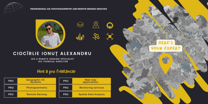
Welcome to my GIS world!
I'm Ionuț-Alexandru Ciocîrlie, your go-to professional for a wide range of geospatial services, with over 7 years of dedicated experience.
Whether you need precise GIS Analysis, Detailed Mapping, In-depth Cartography, or Remote Sensing/Photogrammetry processing, I have the knowledge and skills to deliver exceptional results.
My Expertise and Services:
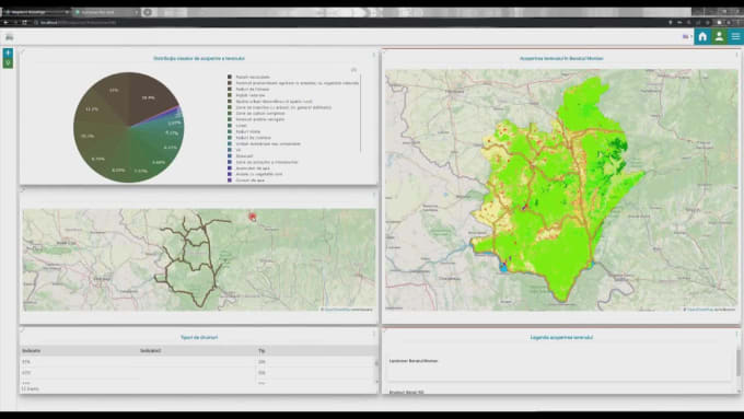
- GIS Analysis: Find properties with precision, Our GIS Analysis considers zoning, proximity, and more, ensuring smarter real estate investments.
- Web GIS Applications: Elevate your projects with our Web GIS Applications. Harness geospatial data for dynamic mapping, visualization, and spatial analysis.
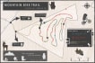
- Mapping and Cartography: I craft accurate and visually captivating maps and cartographic representations.
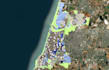
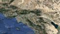
- Satellite Imagery Interpretation and processing: Expert in interpreting and processing satellite imagery, extracting valuable insights for your projects.
- Drone Imagery Processing: I provide end-to-end drone imagery services, from acquisition to interpretation and analysis.
- Geomorphology and Terrain Analysis: Specializing in terrain mapping and detailed geomorphological analysis.
Get to know Ciocirlie I.
Ciocirlie I.
Pro
Geospatial Expert
Top Rated
Ciocirlie I. is part of the Fiverr Pro catalog and has been hand-picked by a dedicated Fiverr Pro team for their skills and expertise.
Expert in:
Data Visualization
- FromRomania
- Member sinceJul 2017
- Avg. response time1 hour
- Last delivery1 week
Languages
English, Romanian
Welcome to my GIS world!
I'm Ionuț-Alexandru Ciocîrlie, a seasoned GIS Expert with academic roots in Geography and Geospatial Sciences.
My journey began as a consultant on the groundbreaking Copernicus program's Coastal Zone LCLU project in Europe. With experience at esteemed organizations like the Romanian Defense Geospatial Information Agency or leading private companies.
Choose me for professionalism, quality, timely delivery, and clear communication.
Let's transform your geospatial needs with precision and innovation.
FAQ
What is GIS analysis, and how can it benefit my project?
GIS analysis involves leveraging geographic data to solve complex problems. It can benefit your project by providing insights into spatial relationships, optimizing resource allocation, and aiding in data-driven decision-making.
How do you ensure the accuracy of your maps and cartographic representations?
I ensure accuracy through meticulous data collection, advanced georeferencing techniques, and rigorous quality control processes. Your maps will be reliable and precise.
Can you provide an example of a project involving satellite imagery interpretation?
Certainly! I've used satellite imagery to assess deforestation rates in a tropical rainforest, helping organizations make informed conservation decisions.
What industries can benefit from drone imagery processing and interpretation?
Drone imagery is valuable across various sectors. Examples include construction site monitoring, agriculture for crop health assessments, and infrastructure inspection.
How do you source geospatial data for projects?
I utilize a combination of open-source data, remote sensing technologies, and proprietary datasets to gather accurate and up-to-date geospatial information tailored to your project's needs.
What types of remote sensing analyses can you perform?
I can conduct various remote sensing analyses, such as land cover classification, change detection, and thermal imaging, depending on your project's objectives.
How can Geographic Information Systems (GIS) enhance decision-making in real estate development?
GIS aids in site selection, market analysis, and property valuation, providing valuable insights for informed real estate development decisions.
What are the key advantages of geospatial services in environmental monitoring and conservation?
Geospatial services enable real-time tracking of environmental changes, helping conservationists identify endangered habitats and monitor ecosystem health.
Reviews
50 reviews for this Gig
| (49) | ||
| (1) | ||
| (0) | ||
| (0) | ||
| (0) |
Rating Breakdown
- Seller communication level
- Recommend to a friend
- Service as described
Sort By
Most relevant
m markventurella

United States
Great job, delivered early and exceeded expectations. will definitely work with him again
$800-$1,000
Price
6 days
Duration
Helpful?r ryanhuang475

Canada
absolutely incredible work
$400-$600
Price
2 days
Duration
Helpful?k kyleharper561
United States
This was a great experience. Delivered three maps, fairly complicated, and was able to help communicate the ideas I needed to communicate in visual fashion very clearly and effectively. Delivered on time and to specification, would definitely use again next time.
$400-$600
Price
4 days
Duration
Helpful?a alexdiaz192
Repeat Client

United Arab Emirates
Exceptional as always
$100-$200
Price
4 days
Duration
Helpful?a alexdiaz192
Repeat Client
United Arab Emirates
Again, exceptional and high quality work from Ciocirlie. Will choose to work with him again
$200-$400
Price
7 days
Duration
Helpful?
Reviews
50 reviews for this Gig
| (49) | ||
| (1) | ||
| (0) | ||
| (0) | ||
| (0) |
Rating Breakdown
- Seller communication level
- Recommend to a friend
- Service as described
Sort By
Most relevant
m markventurella
United States
Great job, delivered early and exceeded expectations. will definitely work with him again
$800-$1,000
Price
6 days
Duration
Helpful?r ryanhuang475
Canada
absolutely incredible work
$400-$600
Price
2 days
Duration
Helpful?k kyleharper561
United States
This was a great experience. Delivered three maps, fairly complicated, and was able to help communicate the ideas I needed to communicate in visual fashion very clearly and effectively. Delivered on time and to specification, would definitely use again next time.
$400-$600
Price
4 days
Duration
Helpful?a alexdiaz192
Repeat Client
United Arab Emirates
Exceptional as always
$100-$200
Price
4 days
Duration
Helpful?a alexdiaz192
Repeat Client
United Arab Emirates
Again, exceptional and high quality work from Ciocirlie. Will choose to work with him again
$200-$400
Price
7 days
Duration
Helpful?
