Browse categories
I will create gis map, geospatial analysis, imagery analysis

Bramantiyo M
Level 2
Bramantiyo M
Level 2


About this gig
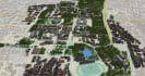
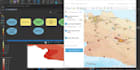
as described in the offered packages, I will do any GIS and remote sensing related tasks with various output ranging from geospatial data production, maps layouts, and GIS analysis from simple geoprocessing to advanced level analysis. I also capable to develop web Map or Web GIS using well-known Mapping Framework such as Leaflet JS, OpenLayers, or ArcGIS Maps SDK for Javascript.
if you want to know more about my skills, I have a YouTube channel which showcase my skills at https://youtube.com/c/geo2004. Some of the jobs I have done in fiverr also showcased in my fiverr profile portofolio,
If you want to use my services, you must provide all the needed data for input and processing, unless the data are easily obtainable from internet and have public domain level data access, I will gladly helping procure the data.
Don't hesitate to contact me for further clarification and information about what I am offering. Thank you and have a nice day.
Get to know Bramantiyo M
Bramantiyo M
Level 2
- FromIndonesia
- Member sinceApr 2022
- Avg. response time1 hour
- Last delivery1 month
Languages
English, Javanese, Indonesian
I am graduated from geography department of gadjah mada university indonesia and diponegoro university indonesia for my master programme in Urban and regional Planning. I have expertise in GIS, Remote Sensing, GNSS, Web Mapping, Python Programming, and their applications on Urban and regional mapping, geography, disaster analysis, geospatial data production, you name it,
- Build WebMap Using LeafletJS
- Develop a Cartographic Products
- Wells distributions WebMap App
- Heatmap App Using Leaflet JS
- Sea Level Rise Impact Viewer App
FAQ
What are GIS and Mapping software you are capable of using?
besides ArcGIS, I can use QGIS, ESA-SNAP, ENVI, ERDAS, basically all of GIS and Remote Sensing either proprietary or Open Source I can use and learn for a short of time.
Can you provide Map Making, Design and output data/information products in non GIS-based software?
Yes, I can provide map in common presentation formats such as Adobe Illustrator (AI), Adobe Photoshop (PSD), PDF and GeoPDF, Graphics Vectors (SVG, Corel), CAD (DWG, DXF), PowerPoints, etc, for you if you want it.
Reviews
29 reviews for this Gig
| (29) | ||
| (0) | ||
| (0) | ||
| (0) | ||
| (0) |
Rating Breakdown
- Seller communication level
- Recommend to a friend
- Service as described
Sort By
Most relevant
 United Arab Emirates
Prefect, as expected.
 United States
Excellent work provided with a very quick turnaround. Highly recommend!
- United Arab Emirates
Always, output is as expected, if not exceeded.
- United Arab Emirates
Always, output is as expected, if not exceeded.
 Malaysia
Love working with Bram, this is my second time. Will definitely come back.
Reviews
29 reviews for this Gig
| (29) | ||
| (0) | ||
| (0) | ||
| (0) | ||
| (0) |
Rating Breakdown
- Seller communication level
- Recommend to a friend
- Service as described
Sort By
Most relevant
- United Arab Emirates
Prefect, as expected.
- United States
Excellent work provided with a very quick turnaround. Highly recommend!
- United Arab Emirates
Always, output is as expected, if not exceeded.
- United Arab Emirates
Always, output is as expected, if not exceeded.
- Malaysia
Love working with Bram, this is my second time. Will definitely come back.
